As many of you know, I recently climbed Glacier Peak to raise money in support of the Fred Hutchinson Cancer Research Center. The climb was a stunning success, and I want to thank all of you who generously supported my fundraising efforts. I also want to share some of the details of my journey with you.
Climbing Glacier Peak was one of the most challenging, rewarding, and memorable experiences of my life. At 10,541 feet, Glacier Peak is the fourth highest mountain in Washington and the most isolated of the Cascade’s volcanoes. Given its remote location, it took us five days to complete the climb. This is my account of those unforgettable five days.

Preparing for the Unknown
I was a bit nervous in the weeks before the climb, largely because I wasn’t sure if I was prepared for the expedition. I tried my best to squeeze in as many hikes and backpacking trips as I could, which wasn’t too difficult given that summer in Alaska is a hiker’s paradise. I did, however, have a hard time simulating the heavy pack I knew I’d have to lug up to the top of the mountain. I brought as much gear on my training hikes as I could possibly fathom carrying, but still my pack weighed significantly less than the 60-65 pounds that Alpine Ascents—our guiding company—told us we should be ready for. The following excerpt from the information packet we received should give you an idea of what I was up against:
This 5-day climb of the Disappointment Cleaver route on Glacier Peak is a serious undertaking. Just because you exercise regularly (4–6 times per week) does not mean you have the conditioning needed to climb Glacier Peak. Plenty of people who can run a marathon fail to summit this mountain. Pure cardiovascular fitness is simply not enough. You need to be able to ascend 4–5,000 feet in successive days with substantial weight on your back. Expect to carry at least a 55–65 pound pack of tents, gear, and food (or more) to get in to base camp. . . . A reasonable goal a month before your climb would be to ascend 3,000–4,000 feet carrying an average pack of 60–65 pounds in a 2-3 hour period, or roughly 1,250 vertical feet in an hour.
As you can see, I had good reason to be concerned about my physical preparations.
For my final training hike, Nathan and I decided to make the grueling hike up to Pioneer Ridge, a steep trail located just outside the nearby town of Eagle River. The trail gains just over 5,000 ft. over roughly four miles as it ascends from the floor of the Matanuska Valley  up to a stunning alpine ridge overlooking the massive Knik Glacier. While the switchbacks seemed never ending on the way up, the hike down was even more excruciating. And even though I was only carrying a moderate day pack, I spent the next several days waddling around like a penguin because my legs were so sore. Needless to say, I was worried about my upcoming climb. Still, I pushed through the soreness and kept up on my daily runs for the rest of the week. I knew that I needed to be strong not only for myself, but also for the rest of my team. [SPOILER ALERT: I survived]
I flew from Anchorage to Seattle early Tuesday morning, and spent the rest of the day frantically checking and rechecking my gear list. I laid out all of my supplies in the middle of my parents’ living room, and I could tell that mom and dad were a bit skeptical as to whether I’d be able to fit it all in my climbing pack.

Day 1: Gear Check and the First Five Miles
I awoke at around 4 a.m. the next morning and took one last shower before heading to the Alpine Ascents office in downtown Seattle for a 3-hour mandatory gear check. Although I’d met two of the other climbers this past fall during an avalanche course—including Marybeth, who first told me about Fred Hutch and the Climb to Fight—this was my first introduction to the seven remaining climbers and the three guides I’d be spending the next five days with. It quickly became clear that I was the most inexperienced in the group, as everyone else had done several similar climbs before, such as Mt. Baker, Mt. Adams, and Mt. Rainier. My only consolation was that unlike the other classic Cascade volcanos, the remoteness of Glacier Peak means that only a small part of ascending this particular peak entails true climbing; the rest involves extended backpacking, something I’ve become intimately familiar with as a result of my time on the John Muir and Pacific Crest trails.
During gear check, we went through each item on our extensive gear list and showed them to our lead guide, Devin, for approval. The forecast was for good weather, so thankfully he told us we could leave several things behind—including our “disaster mittens” and ski goggles, for example. As a result, my pack weighed “only” 40 or 50 pounds as we began the long drive north. After leaving the small logging town of Darrington, we took the Mountain Loop Highway as it wound alongside the scenic Sauk River and eventually arrived at the Sloan Creek trailhead. There, the guides gave each of us our portion of the group gear to carry. I’m sure the snow shovel and assorted cooking supplies I was assigned made up for the weight I’d removed earlier. And although I didn’t know it at the time, we never ended up even using the shovel! But of course, C’est la vie.
My parents—who planned to camp in their motorhome for the next week and do a series of day hikes nearby—met up with our group at the trailhead to send us off. They offered to watch over some of the group’s valuables, and also to make sure the cooler of beer Marybeth had been forward-thinking enough to bring for our return remained stocked with ice.
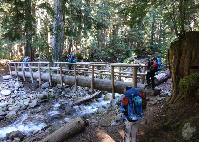
It was well past noon and quite warm by the time we finally left the trailhead, so it was a relief that we only had a five-mile, relatively flat hike through a shaded forest before reaching our first camp at the Mackinaw Shelter. We all knew that tomorrow would be a strenuous day—starting with a 3,000 ft. climb over 2.5 miles—so as soon as we finished dinner, we crawled into our 3-person tents and tried to get as much rest as we could.
Day 2: Up (and Up and UP) to White Pass and the Long Trek to Base Camp
The next morning, we packed up camp as quickly as possible, hoping to avoid doing the steep switchbacks in the heat of the day. We braced for the worst, and were pleasantly surprised to find that much of the ascent was at least partially shaded. Still, it was exhausting carrying a full load of food, climbing gear, and camping supplies, and I was grateful that our guides had a policy of stopping every hour to rest, refuel, and hydrate.
 As we climbed switchback after switchback, the views began to improve. By the time we gained the top of the ridge, we were traversing through alpine meadows filled with brilliantly colored wildflowers, and the panoramic views of the surrounding mountains made the effort well worthwhile.
We soon intersected the Pacific Crest Trail, a bustling highway as trails go, which we  followed along the ridge for a short distance until reaching White Pass. Although this is the end of the official trail, we continued along a well-established climber’s path as it traversed for a mile or so along the east side of White Mountain and reached a saddle where we finally had our first view of Glacier Peak. Although it was a magnificent sight, I was alarmed by how far away the mountain still seemed.
The trail became steeper and less pronounced as we descended into the adjacent drainage and climbed up and over the next pass, and was almost nonexistent by the time we ascended up and over a final saddle and into an expansive, boulder-filled basin at the  foot of the rapidly receding White Chuck Glacier. It had been a long and exhausting day, so we were greatly relieved when our guides announced that this would be our base camp for the next two nights.
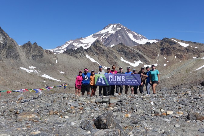
As we set up our tents alongside one of the many tarns scattered throughout the rocky plateau, we all took stock of our dramatic surroundings. There were breathtaking vistas in every direction, from the glaciated face of Glacier Peak directly to our North to the White Chuck Glacier immediately East of our camp, to the endless peaks comprising the Cascade Range to the West. I spent the next several hours wandering around the basin, taking pictures and soaking in the raw beauty of the place.
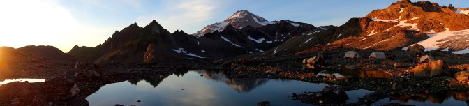
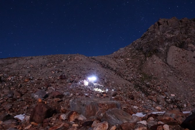
I knew I needed a good night’s rest for our summit attempt the following day, but I still couldn’t resist staying up and taking a few photographs of the dazzling night sky. The Perseid meteor shower was supposed to be visible the week of our climb, and we happened to be camped in one of the most remote wilderness areas in Washington! Although I didn’t manage to capture any on camera, it wasn’t long before I saw a meteor blaze across the sky.
![]()
Day 3: SUMMIT DAY
The original plan had been to get up before dawn and summit on our fourth day, but because we’d made such good progress the day before, our guides decided we should try for the summit on day three instead. That way, we wouldn’t have to summit, pack up our basecamp, and hike halfway back to the trailhead all in one day. We could also avoid getting up in the dark (called an “alpine start”), which everyone seemed to be excited about. While I liked the idea of sleeping in, I must admit I was somewhat disappointed because the thought of making our way up the mountain with only our headlamps to light the way seemed thrilling—and also a key part of the classic climbing experience. As I’ll explain later, however, I ended up getting my wish (well, sort of).
As I ran around frantically that morning trying to get my gear organized for the climb, I noticed that everyone else seemed to know the drill. I kept asking the others, How should I carry my harness? Where does my helmet go? Should I bring my hiking poles? I checked and rechecked my gear, and as we finally left camp around 10 a.m., I crossed my fingers that I hadn’t left anything crucial behind.

In many ways, the first (and last) three miles of the climb that day were the toughest, as it required crossing a seemingly endless boulder field. Although we did occasionally see signs if a faint climber’s trail, there was no clear route and the instability and unevenness of the rocks made for slow going. By the time we finished the climb up to Glacier Gap, a popular spot for setting up base camp higher up on the mountain, we were quite a bit behind schedule. Still, the weather was fabulous and we each had our headlamps in case we didn’t make it back to camp before dark, so nobody was too worried.
After gaining the saddle at Glacier Gap (elevation 7,200 ft.), we descended slightly and  began making our way across the Suiattle Glacier, following a fairly well-defined trail of footprints across the snow. The path left the glacier briefly as it made slow switchbacks
along the ridge and up to Disappointment Peak. Near the top of the ridge, at about 8,400 ft., we cut over onto the Gerdine Glacier and stopped to put on our climbing gear. Our guides checked over our harnesses, helmets, and crampons, and then arranged us into three roped teams. Being the “newbie” with the least experience, the lead guide placed me immediately behind him on the first roped team so he could show me the  ropes (literally). We went over how to use my ice ax for self-arrest in the event of a slide, as well as the proper spacing between other climbers during glacier travel. I may have had to concentrate a bit harder than the others, but I got into the swing of things as we made our way higher up the glacier.
At about 9,200 ft., we encountered a series of crevasses as the route narrowed to a small col at the base of Disappointment Peak. I tried my best to focus on my steps, but found myself gaping in amazement at these deep cuts in the ice. Although the crevasses were a fraction of the size found on many other mountains, and not nearly as dangerous, I was still captivated by them. We waited for the other teams to make it safely past the crevasses before continuing around Disappointment Peak and up the Cool Glacier (you can’t beat a name like that!). We could see the summit now, and it felt so close. But we still had about 700 ft. to climb, and I knew the last section would be challenging.
![]()
At the top of the glacier, we unroped and began walking on the crest of the narrow ridge leading up to the summit. Our muscles were screaming and our bodies were exhausted by the time we reached the final snow-filled gully just below the summit. We kicked steps in the steep snow slope, and my heart was pounding both from exertion and also from the exposure and the fear of what would happen if I fell at that point. I forced myself to focus on one step at a time, and before long I heard someone above me yelling that they’d reached the summit.
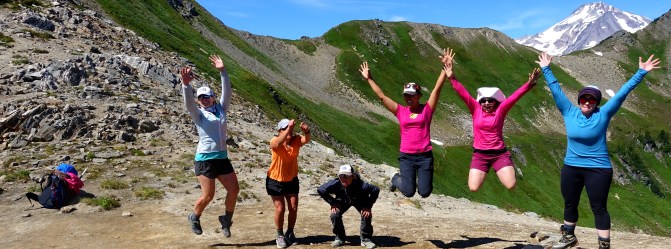
The feelings of accomplishment and relief were overwhelming, and I will admit my eyes were a bit watery as I climbed those final steps onto the summit. We congratulated each other with big hugs and later cheered the others on as they arrived at the top.
The views in all directions were even more impressive than I imagined. As I stood there at 10,541 ft.—on top of the fourth highest mountain in Washington—I could see for more  than a hundred miles in every direction. I recognized many of the Cascade’s great peaks, including Mount Rainier and Adams to the South, Mount Stuart to the Southeast, and Mount Baker and Shuksan to the Northwest. As much as I love Alaska and its vast mountain ranges, I grew up with the Cascades in my back yard. You can actually see the snow-covered face of Glacier Peak from my parents’ house. So even though part of me felt like I was standing on another planet, I had the strange sensation that I was right at home, surrounded by familiar friends. It was a feeling I’ll never forget.
 After snapping a few more pictures, we began our long trek down to camp. Although I did
require some encouragement from our guides as I descended the steep snow chute below the summit, I was eventually able to relax and gain confidence in the stability of my steps.
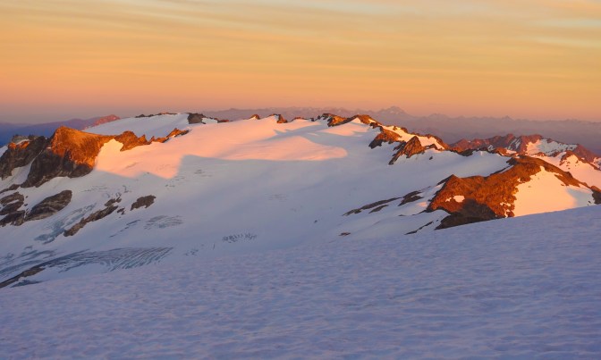
Shortly after we reached the Cool Glacier and separated into our roped teams, an orange glow began to spread across the mountain landscape. The colors of the sunset intensified as we made our way down the glacier.
![]()
The scene before us was sublime, and we walked in almost complete silence as we gazed at our surroundings. Although I knew it meant we would be making much of the descent in the dark, the beauty of that hour before sunset more than made up for our late start that morning. I have no doubt the sight of that alpenglow blanketing each of the surrounding peaks is one I will remember vividly for the rest of my life.
The darkness began to settle in around the same time that we reached the end of the
glacier and removed our climbing gear. As tired as I was, I forced myself to pull out my tripod during one of our rest breaks and capture a few pictures of the last members of our team making their way down the mountain.
![]()
We were all becoming increasingly exhausted with each step, but everyone’s spirits were still flying high after our successful climb. Crossing the boulder field proved to be especially difficult and tiresome, and even though we were moving very slowly, a few members of the team had minor falls when they twisted their ankles or tripped over an unstable rock. The darkness, the instability of the terrain, and our own exhaustion made for a bad combination, and we were honestly a bit surprised that nobody suffered any real injuries during those last few miles.
It was almost 1:30 a.m by the time we finally stumbled into our camp, and if our guides hadn’t forcefully reminded us that we needed to eat to refuel our bodies after 15 hours of strenuous exercise, I think most of us would have gone straight to sleep without dinner. Still, the whole team was in amazingly good spirits when we crawled into our tents for a well-deserved night’s rest.
Day 4: Recovery and the Return to White Pass
We slept in late the next day and had a wonderfully lazy morning, lounging in the sun and sharing random stories from the night before. It was nearing mid-day by the time we finally built up enough energy to pack up camp and begin the trek back to White Pass. I’m sure it’s just because our bodies were so tired by this point, but it felt like a much longer hike than it had on the trip up. The scenery was just as beautiful, though, and that helped keep us going.
After what felt like an eternity but was probably only a few hours, we arrived at the group  camping area near White Pass. As it turns out, this is one of the bigger camping hubs along the Pacific Crest Trail—a sort of metropolis by trail standards—and it brought back a flood of memories from the time I spent on the PCT last summer. We shared our final dinner together and then sat watching the sunset over the neighboring peaks. For the first time on this trip, I decided to cowboy camp—which basically just means sleeping on the ground sans the tent. I watched the stars as I fell asleep, reflecting on the experiences of the last few days.
Day 5: Big Hugs and Cold Beer at the Finish Line
 We were so ready for greasy food and a shower on that last day that we almost raced the remaining 9 miles back to the trailhead, making only brief stops to grab snacks and refill our water supplies. My parents had hiked in to meet us, and we ran into them when we were about a mile or two from our cars. Everyone was happy to see their familiar faces, especially because it meant we were so close to a cooler filled with ice-cold beer. There were plenty of hoots and hollers when the parking lot came into view, and those of us who got there first made sure we had cold beers ready for the rest of the group as they arrived.

We all met for burgers in Arlington before going our separate ways. Before saying goodbye, I made a point of telling each of my new friends how wonderful they had been and what a privilege it was to climb with them. I couldn’t have asked for a better group of people to spend the last five days with, and I am confident we’ll stay in touch going forward. It’s not every day that you meet so many warm, kind-hearted individuals. But then again, it’s not everyone who’s willing to climb a mountain to fight cancer. I’m so proud of this group, and I can’t wait to do it again.
(P.S. For those of you who wanted to donate but didn’t get the chance, you can still do so by clicking here!)
